Only released in EOL distros:
Package Summary
2D/3D mapper based on libpointmatcher (http://github.com/ethz-asl/libpointmatcher)
- Author: François Pomerleau and Stéphane Magnenat
- License: BSD
- Source: git https://github.com/ethz-asl/ethzasl_icp_mapping.git (branch: None)
Package Summary
2D/3D mapper based on libpointmatcher (http://github.com/ethz-asl/libpointmatcher)
- Author: François Pomerleau and Stéphane Magnenat
- License: BSD
- Source: git https://github.com/ethz-asl/ethzasl_icp_mapping.git (branch: None)
Package Summary
2D/3D mapper based on libpointmatcher (http://github.com/ethz-asl/libpointmatcher)
- Maintainer status: maintained
- Maintainer: Francois Pomerleau <f.pomerleau AT gmail DOT com>
- Author: François Pomerleau and Stéphane Magnenat
- License: new BSD
- Source: git https://github.com/ethz-asl/ethzasl_icp_mapping.git (branch: hydro_devel)
Contents
Overview
One of the main problems with point-cloud registration solutions is that their efficiency often depends on the application. This package provides a convenient way to tune, test and deploy several registration solutions using the same node. It provides a real-time tracker and mapper in 2D and 3D, based on the libpointmachter and libnabo libraries. This allows a complete configuration of the registration chain through YAML files, see the chain configuration page for a list of modules and their parameters. You can think of this package as the front end of a SLAM system, including everything but loop-closure detection and relaxation.
For installation instructions, see the ethzasl_icp_mapping stack page. A preliminary version of this package was deployed in the ROS kinect contest.
Citing
Two papers talk about our open-source ICP library. The first one introduces the library and proposes a sound evaluation methodology using it. It was published in Autonomous Robots and can be found here (full text):
@ARTICLE{pomerleau13comparing,
   Author = {F. Pomerleau and F. Colas and R. Siegwart and S. Magnenat},
   Title = {Comparing ICP variants on real-world data sets},
   Journal = {Autonomous Robots},
   Volume = {34},
   Number = {3},
   Month = {April},
   Year = {2013},
   Pages = {133--148}
}
In addition, a paper using a preliminary version of this package to evaluate a Kinect tracker was presented at IROS 2011 and can be found here (fulltext):
@INPROCEEDINGS{pomerleau11tracking,
    author = {François Pomerleau and Stéphane Magnenat and Francis Colas and Ming Liu and Roland Siegwart},
    title = {Tracking a Depth Camera: Parameter Exploration for Fast ICP},
    booktitle = {Proc. of the IEEE/RSJ International Conference on Intelligent Robots and Systems (IROS)},
    publisher = {IEEE Press},
    pages = {3824--3829},
    year = {2011}
}
Quick Start
Since the proposed ICP chain is highly modular, it has many parameters. You can play with it directly if you have an openni-compatible sensor:
roscd ethzasl_icp_mapper
roslaunch launch/openni/tracker_viewer.launch
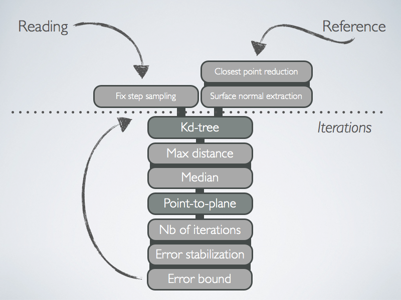
You can then have a look into the launch/openni/ files to see how the openni tracker is configured. This file roughly corresponds to the following chain:

Starting from this chain, you can develop your own chain.
Nodes
mapper
This node performs continuous registration of point clouds and publishes the resulting pose using tf and through nav_msgs/Odometry messages. The type of topic messages must be sensor_msgs/LaserScan (2D) or sensor_msgs/PointCloud2 (2D or 3D). This effectively implements a real-time tracker in 2D or 3D.Subscribed Topics
/scan (sensor_msgs/LaserScan)- If parameter ~subscribe_scan is true, the topic on which laser scans (2D) are received.
- If parameter ~subscribe_cloud is true, the topic on which point clouds (2D or 3D) are received.
Published Topics
/point_map (sensor_msgs/PointCloud2)- Resulting map (2D or 3D depending on incoming data)
- sensor to map frame odometry message
- odom to map frame odometry message
Services
dynamic_point_map (map_msgs/GetPointMap)- Return the built map
- Save the built map to the disk
- Load a map from the disk, reset odom-to-map transform to identity
- Clear the map and reset odom-to-map transform to identity
- Set the odom-to-map transform
- Set the localizing/mapping mode
- Get the current localizing/mapping mode
Required tf Transforms
sensor frame → /odom- sensor to odom frame transform, input from odometry
Provided tf Transforms
/odom → /map- odom to map frame transform, result of ICP
Parameters
~icpConfig (string, no default)
Name of the YAML file configuring the modular ICP chain, see Configuration section.
~useROSLogger (bool, default: false)
- If true, use ROS console for logging, otherwise use logger defined in config file.
~cloudTopic (string, default: "/camera/rgb/points")
The node listens to the topic whose name is defined by this parameter and expects a sensor_msgs/PointCloud2.
~deltaPoseTopic (string, default: "/openni_delta_pose")
- Topic on which to send delta pose.
~fixedFrame (string, default: "/world")
Frame name used as fixed frame in the tf published by the node.
~sensorFrame (string, default: "/openni_rgb_optical_frame")
Frame name used as moving frame in the tf published by the node.
~startupDropCount (unsigned, default: 0)
- Number of clouds to drop on startup, useful if sensor is producing garbage in a startup phase.
Node: matcher_service
This node provides a service to match two point clouds.
Services offered
match_clouds (ethzasl_icp_mapper/MatchClouds.srv - custom messages in the package)
This service takes two sensor_msgs/PointCloud2 messages as inputs (the first is the reference and the second the reading) and provides a geometry_msgs/Transform message as output. The resulting transformation can be used to move the reading point cloud.
Parameters
As with the mapper node, the chain is configured through a YAML file.
~config (string, no default)
Name of the YAML file configuring the modular ICP chain, see ICP chain configuration file.
~useROSLogger (bool, default: false)
- If true, use ROS console for logging, otherwise use logger defined in config file.
Node: occupancy_grid_builder
This node builds a 2D nav_msgs/OccupancyMap from sensor_msgs/LaserScan. It is yet to be fully documented.
Limitations
This library solely performs point-cloud registration, it does not incorporate data fusion based on IMU or odometry. This can be done through other nodes such as robot_pose_ekf.
Known bugs
The version released in ROS does not work in 2D, please use the latest git master version for this use case.
Report a Bug
Please report bugs and request features using the github page.


